
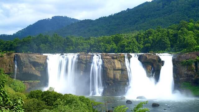
Athirappilly Waterfall
Athirappilly · Chalakudy · PIN 680721
Athirappilly Waterfall is Kerala’s largest waterfall, dropping about 80 feet on the Chalakudy River amid the forested Sholayar ranges of…
View tourist placeExplore Taluks, cities, towns, villages, localities and areas recorded under PIN 680721 in Thrissur district.
Explore Taluks, towns, villages, localities and useful services connected with this postal area.
Choose a category to view public-service listings for this PINCODE, including available contact and location details.
Discover tourist attractions and visitor destinations listed under PINCODE 680721 in Thrissur district.
Athirappilly · Chalakudy · PIN 680721
Athirappilly Waterfall is Kerala’s largest waterfall, dropping about 80 feet on the Chalakudy River amid the forested Sholayar ranges of…
View tourist placeCharpa · Chalakudy · PIN 680721
Charpa Falls is a popular roadside waterfall on the forest route between Athirappilly and Vazhachal in Thrissur district, Kerala. The…
View tourist placeMalakkappara · Chalakudy · PIN 680721
Malakkappara is a quiet tea-growing hill destination in Thrissur district near the Kerala–Tamil Nadu border. Surrounded by Western Ghats forests,…
View tourist placeThumboormuzhi · Chalakudy · PIN 680721
Thumboormuzhi Dam and Butterfly Garden is a family-friendly nature stop on the Chalakudy River in Thrissur, Kerala. The site combines…
View tourist placeVazhachal · Chalakudy · PIN 680721
Vazhachal Waterfalls is a scenic Chalakudy River attraction near Athirappilly in Thrissur, Kerala, where water rushes across a broad rocky…
View tourist placeAthirappilly Road, Chalakudy · Chalakudy · PIN 680721
Dream World Water Park on Athirappilly Road near Chalakudy is a family-oriented recreational attraction in Thrissur district. The park combines…
View tourist placeUse the filters to narrow local places by name, place type or Taluk.
No matching local records
This PINCODE is recognised, but detailed Taluk, city, town, village, locality and area information is still being prepared.
Review available PIN information, local geography, source dates and correction options.
Send the correct place name, type, Taluk, PIN and a supporting source. Corrections are reviewed before the district geography record changes.
Your feedback helps us improve useful local district information.
Be the first to share feedback on this page.